
 English
 Español
 Deutsch
 日本語
日本語 Polska
 Français
 中國
中國 한국의
한국의 Українська
 Italiano
 Nederlands
 Türkçe
 Português
 Bahasa Indonesia
 Русский
 हिंदी
हिंदीMontreal - 3D City Model Лоу-поли 3D Модель


$
399.00 USD
У вас есть $0.00 Кредиты. Купить Кредиты

- Доступные форматы: Autodesk 3DS MAX (.max) 339.06 MB
- Полигоны:1
- Вершины:1
- Анимированная:
- Текстуры:
- Скелет:No
- Материалы:
- Лоу-поли:
- Коллекция:No
- UVW mapping:
- Плагины:No
- Для печати:No
- 3D Скан:No
- Контент для взрослых:No
- PBR:
- AI Обучение:
- Геометрия:Polygonal
- Unwrapped UVs:No
- Просмотры:1588
- Дата: 2024-01-22
- ID Продукта:488218
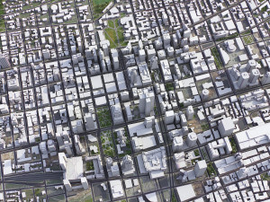
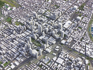
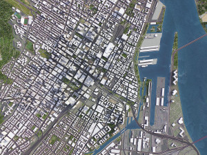
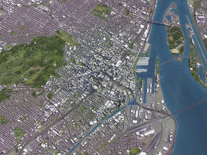
Montreal - 3D City Model 3D Модель max, от 3d.city.models
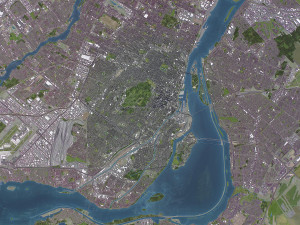
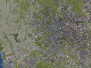
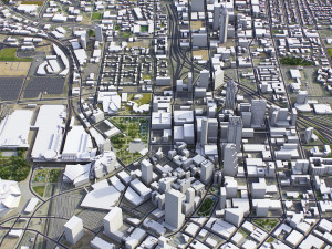
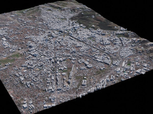
TOP-QUALITY 3D CITY MODEL - 2024 UPDATE- Message us to get a FREE sample scene of this product!
- Download an overview sample - https://each.city/sample
- 24/7 customer support — customization, flexible pricing and exclusive discounts
WHAT IS INCLUDED
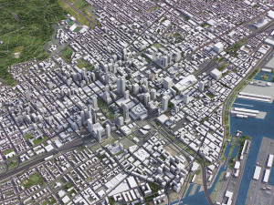
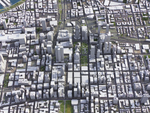
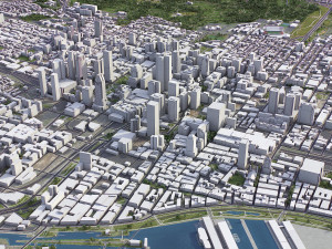
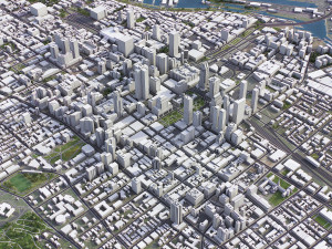
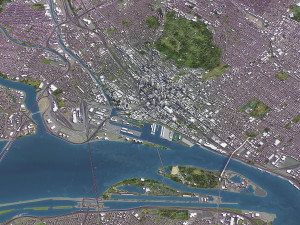
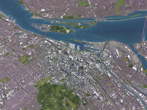
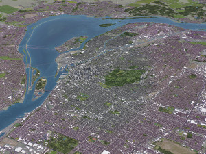
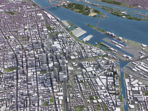
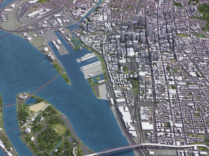
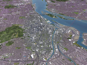
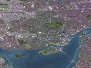
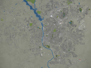
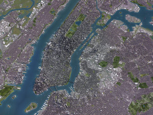
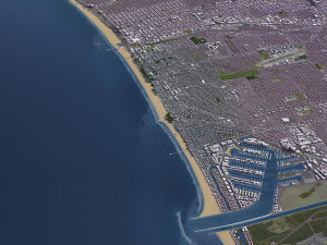
- Scene size: Entire area — refer to promo images for scene extents
- Units: Meters — real-world scale
- Updated: January 2024 — want the latest? Ask before you pay
KEY BENEFITS
- 24/7 customer support — reach out to us anytime for pre-sale inquiries or after-sale support
- Extensive file format support — 3ds Max (native), fbx, obj, dae, c4d, skp, 3dm, rvt, blend, etc., or ask for more before payment
- Georeferencing — either Web Mercator, Trаnsverse Mercator, or original CRS. If a specific CRS is essential, ask before you pay
- Any scene size or crop to an area-of-interest — for best performance and format compatibility, inquire before paying
- Buildings, land-use areas, roads and railways split by type — layers / named objects
- Detailed landmarks with regular updates and improvements — available annually or upon pre-purchase inquiry
- Realistic and detailed surface texture — 1-meter resolution satellite imagery
- Flat surface, easy for detailing and geometry edits — topography terrain available at an additional cost. Message us for a quote
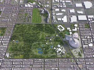
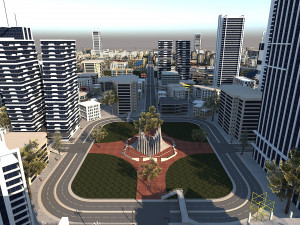
- Realistic low-poly vegetation — individual trees in max and fbx formats, additional formats upon request before you pay
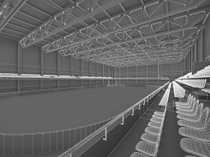
- Product is ready to render out-of-the-box — 3ds Max + Corona Render
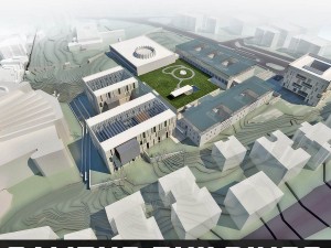
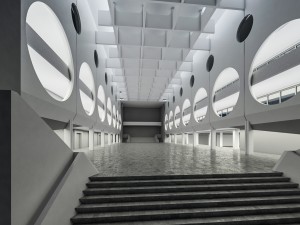
PRESENTATION IMAGES & MATERIALS
- 4K high-resolution renders — refer to images for level of detail and scene size
- Produced in 3ds Max — other software requires its rendering settings
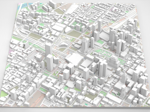
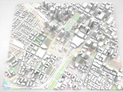
- Trees, vegetation, land-use and airport surface with the textures assigned
- Buildings are UV mapped, split by material IDs, and no textures assigned
CUSTOMIZE & SAVE
- Message us to get a fully customizable model based on the options listed below
- Fast turnaround, flexible pricing and discounts
DATA AUTHENTICITY
- 100% real buildings coverage — unlike other sellers, we don’t use AI generated building footprints
- Combining multiple sources — you may provide us with any dataset to include in the model
GEOREFERENCING and GEOLOCATION - allows you to precisely position 3D content
- Web Mercator / WGS 84 — specified by true scale latitude
- Trаnsverse Mercator — defined by central meridian
- Original CRS — local or optimal for this area
TOPOGRAPHY TERRAIN
- Up to 1-meter accuracy digital terrain model (DTM) — quad mesh
- Multiple terrain LODs — triangle mesh optimized for the best polycount / details balance
- Buildings and roads placed on the optimized terrain
- Separate land surface and water bodies
- High-resolution satellite or surface texture — up to 0.2 meter accuracy
- Contour lines — 3D splines, up to 1-meter interval
MANUAL MODELING
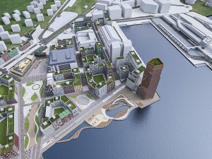
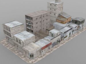
- Buildings and structures — LOD2 and LOD3
- Elevated highways — interchanges, bridges and flyovers
TEXTURING
- High-resolution surface texture — satellite image up to 0.2 meter accuracy
- Streets and roads with markings texture — UV mapped along the center line
- Procedural textures assigned to all buildings — LOD1 only
- Realistic textures on individual buildings — LOD2 and LOD3
TREES & FORESTS
- Individual trees — real trees from OSM data
- Procedural forests — based on distribution areas, convertible to individual trees
OTHER EXTRAS
- Individual buildings and streets — separate objects with address and/or name
- Administrative boundaries of all levels — named polygons or outlines
- Road and railway splines — for traffic animation, etc.
- Public trаnsport stops — individual named objects
FILE FORMATS
- max — Autodesk 3ds Max
- fbx, obj, dae, 3ds — Exchange Formats
- uproject, uasset — Unreal Engine
- glb, gltf — Games, Web, AR/VR
- unitypackage — Unity 3D
- 3dm — Rhino 3D
- skp — SketchUp
- rvt — Autodesk Revit
- c4d — Cinema4D
- blend — Blender
- ma, mb — Autodesk Maya
- dwg, dxf — Autodesk AutoCAD
- stl — 3D Print
Нужно больше форматов?
Если вам необходим другой формат, пожалуйста, сделайте запрос при помощи тикета поддержки. Мы можем cконвертировать 3D модели в такие форматы: .stl, .c4d, .obj, .fbx, .ma/.mb, .3ds, .3dm, .dxf/.dwg, .max. .blend, .skp, .glb. Мы не конвертируем 3d сцены и такие форматы, как .step, .iges, .stp, .sldprt и т. д.!Информация об использовании
Montreal - 3D City Model - Вы можете использовать эту бесплатную 3D модель как в личных, так и в коммерческих целях в соответствии с Базовой или Расширенной лицензией.Базовая лицензия охватывает большинство стандартных вариантов использования, включая цифровую рекламу, проекты дизайна и визуализации, бизнес-аккаунты в социальных сетях, нативные приложения, веб-приложения, видеоигры, а также физические или цифровые конечные продукты (как бесплатные, так и платные).
Расширенная лицензия включает в себя все права, предоставленные в рамках Базовой лицензии, без ограничений по использованию и позволяет использовать 3D модель в неограниченном количестве коммерческих проектов на условиях безвозмездной оплаты.
Подробней
Есть ли у вас Гарантия Возврата Денег?
Если какой либо продукт не соответствует описанию продукта или превью на сайте, мы постараемся исправить это как можно скорей, чтобы вы остались довольны. При условии, что ничего нельзя исправить и вы обратитесь к нам в течении 24 часов, мы отменим ваш платёж и деньги вернутся на ваш счёт. Для получения дополнительной информации, пожалуйста, см. подробней в Центре Помощи.Ключевые слова
city map model area building center skyline landscape topography downtown skyscraper airport urban street sketchup terrain elevation 3d detailed realisticК данному товару нет ни одного комментария.
fbx obj max2016 max2016 3ds dwg
Lycaena
Cityscapes
