English
 Español
 Deutsch
 日本語
日本語 Polska
 Français
 中國
中國 한국의
한국의 Українська
 Italiano
 Nederlands
 Türkçe
 Português
 Bahasa Indonesia
 Русский
 हिंदी
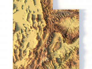
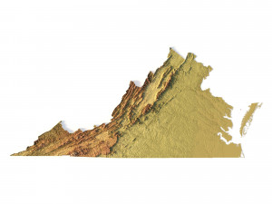
हिंदीModelo STL topográfico do mapa do Colorado Modelo de Impressão 3D


- Solicitar suporte ao produto pelo autor

- Formatos disponíveis:
- ID do Item:402258
- Data: 2022-06-17
- Coleção:No
- Largura em milímetros:312
- Altura em milímetros:5.4
- Profundidade em milímetros:229
- Pronto para impressão:No
- Scan 3D:No
- Conteúdo adulto:No
- PBR:No
- Treinamento de IA:No
- Visualizações:2505
Descrição
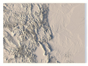
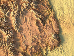
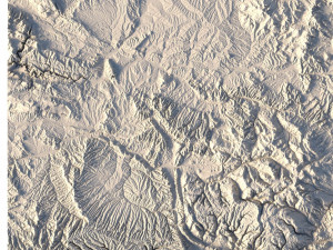
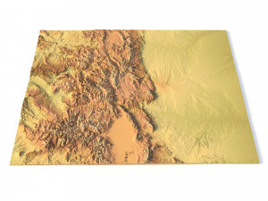
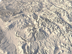
Create Detailed Colorado Terrain Models with This 3D STL
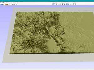
The Colorado Map Topographic STL model provides highly detailed terrain models of the state’s iconic landscape. Ideal for creating raised relief maps from materials like wood, metal, plastic, or concrete, this STL file is perfect for professionals and hobbyists interested in outdoor recreation, geospatial analysis, or landscape visualization. Whether for personal use or professional applications, this model brings the state’s varied landforms to life with precision elevation data.
- File size: 680 MB / 339 MB
- Model size: 312.4 mm x 228.9 mm x 5.374 mm
- Projection: Mercator
- Scaling factor: X — 1; Y — 1; Z — 3
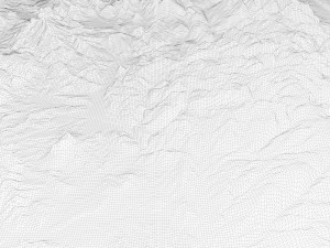
- Polygons: 14 265 976
- Vertices: 7 138 442
- Geometry: Polygonal Tris only
- Base: Open / Closed
Features of the Colorado Topographic STL Model
Compatible with FDM/SLA 3D printing for creating physical models of the terrain.
Designed for CNC machines to carve terrain models from wood or metal.
High-resolution laser engraving for metal surfaces with precise topographic details.
Precisa de mais formatos?
Se precisar de um formato diferente, por favor abra um novo Support Ticket e solicite isso. Podemos converter modelos 3D para: .stl, .c4d, .obj, .fbx, .ma/.mb, .3ds, .3dm, .dxf/.dwg, .max. .blend, .skp, .glb. Conversão de Formato GrátisNão convertemos cenas 3D e formatos como .step, .iges, .stp, .sldprt.!
Informação de utilização
Modelo STL topográfico do mapa do Colorado - Pode utilizar este modelo 3D isento de royalties para fins pessoais e comerciais, de acordo com a Licença Básica ou Prolongada.A Licença Básica abrange a maioria dos casos de utilização padrão, incluindo anúncios digitais, projetos de design e visualização, contas comerciais em redes sociais, aplicações nativas, aplicações web, videojogos e produtos finais físicos ou digitais (gratuitos e vendidos).
A Licença Estendida inclui todos os direitos concedidos ao abrigo da Licença Básica, sem limitações de utilização, e permite que o modelo 3D seja utilizado em projetos comerciais ilimitados ao abrigo dos termos de isenção de royalties.
Leia mais
Vocêm fornecem garantia de devolução do dinheiro?
Sim, fornecemos. Se você comprou um produto e encontrou algum erro nas renderizações ou na descrição, tentaremos corrigir o problema assim que possível. Se não pudermos corrigir o erro, cancelaremos seu pedido e você receberá seu dinheiro de volta em até 24 horas após fazer o download do item. Leia mais condições aquiPalavras-chave
Itens aleatórios do autor