
 English
 Español
 Deutsch
 日本語
日本語 Polska
 Français
 中國
中國 한국의
한국의 Українська
 Italiano
 Nederlands
 Türkçe
 Português
 Bahasa Indonesia
 Русский
 हिंदी
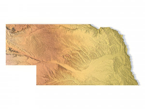
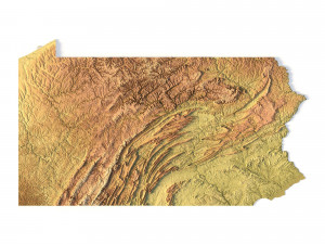
हिंदीMissouri Topographic Map STL Model 3D Baskı Modeli


- Hazır formatlar: Stereolithography (.stl) 683.04 MB
- Koleksiyon:No
- Genişlik (mm):297
- Yükseklik (mm):0.8
- Derinlik (mm):261
- Baskıya Hazır:
- 3D Tarama:No
- Yetişkin(+18) içerik:No
- PBR:No
- AI Eğitim:No
- Görüntülemeler:2489
- Tarih: 2022-06-17
- Ürün ID:402316
Missouri Topographic Map STL Model 3D Baskı Modeli stl, Kimden sychev23021983
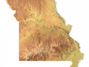
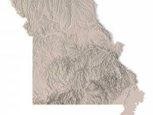
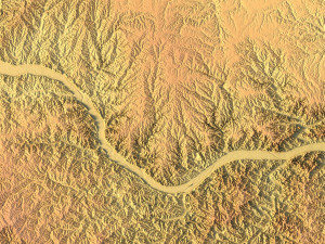
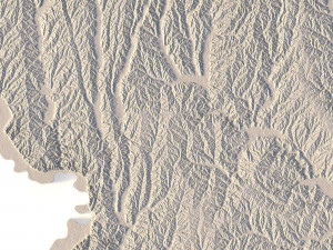
Create Detailed Missouri Terrain Models with This High-Resolution 3D STL
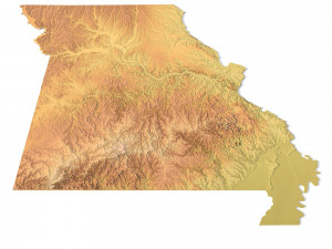
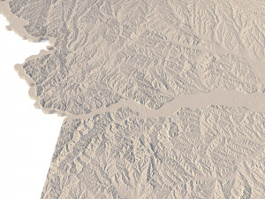
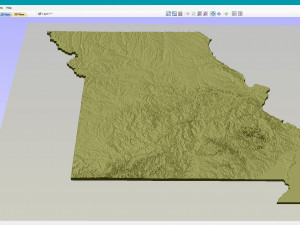
The Missouri Topographic Map STL model provides a high-resolution depiction of the state’s unique topography and geographic features. This 3D model is perfect for creating physical relief maps from materials like wood, metal, plastic, or concrete. Whether you’re using it for landform visualization, educational projects, or professional GIS applications, this model offers accurate elevation data for detailed terrain modeling. It’s ideal for use with 3D printers, CNC machines, and laser engravers.
- File size: 1.21 GB / 621 MB
- Model size: 297.18 mm x 261 mm x 0.768 mm
- Resolution: 0.06 mm
- Projection: Mercator
- Datum: Google maps (sphere radius 6378137)
- EPSG code: 3857
- Scaling factor: X – 0.0000004; Y – 0.0000004; Z – 0.0000012
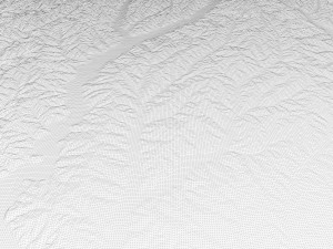
- Number of polygons: 26 079 370
- Number of vertices: 13 051 311
- Polygonal mesh: Triangles only
- Base: Open / Closed
Features of the Missouri Topographic STL Model
Precise elevation data capturing Missouri’s rivers, hills, and flatlands.
Compatible with FDM/SLA 3D printers for creating high-quality terrain models.
Designed for CNC machining to craft detailed relief maps from wood or metal.
Supports high-precision laser engraving for metal surface detailing.
Daha fazla formata mı ihtiyaç duyuyorsunuz?
Farklı bir formata ihtiyaç duyuyorsanız lütfen destek ekibimize bir talep açarak ihtiyacınızı belirtiniz. 3D modelleri şu formatlara dönüştürebiliriz: .stl, .c4d, .obj, .fbx, .ma/.mb, .3ds, .3dm, .dxf/.dwg, .max. .blend, .skp, .glb. 3d sahneleri dönüştürmüyoruz ve .step, .iges, .stp, .sldprt gibi formatlar.!Kullanım Bilgileri
Missouri Topographic Map STL Model - Telifsiz bu 3B modeli, Temel veya Genişletilmiş Lisans uyarınca hem kişisel hem de ticari amaçlarla kullanabilirsiniz.Temel Lisans, dijital reklamlar, tasarım ve görselleştirme projeleri, ticari sosyal medya hesapları, yerel uygulamalar, web uygulamaları, video oyunları ve fiziksel veya dijital son ürünler (hem ücretsiz hem de satılan) dahil olmak üzere çoğu standart kullanım durumunu kapsar.
Genişletilmiş Lisans, Temel Lisans kapsamında verilen tüm hakları, kullanım sınırlaması olmaksızın içerir ve 3B modelin Telifsiz koşullar altında sınırsız ticari projede kullanılmasına olanak tanır.
Daha fazla oku


