English
 Español
 Deutsch
 日本語
日本語 Polska
 Français
 中國
中國 한국의
한국의 Українська
 Italiano
 Nederlands
 Türkçe
 Português
 Bahasa Indonesia
 Русский
 हिंदी
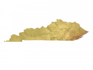
हिंदीModel STL Peta Topografi Kentucky Model Cetak 3D

- Minta dukungan produk oleh penulis

- Format yang tersedia:
- ID Barang:402305
- Tanggal: 2022-06-17
- Koleksi:No
- Lebar dalam milimeter:339
- Tinggi dalam milimeter:1.6
- Kedalaman dalam milimeter:149
- Siap Cetak:
- Pindai 3D:No
- Konten Dewasa:No
- PBR:No
- AI Pelatihan:No
- Tampilan:2340
Deskripsi
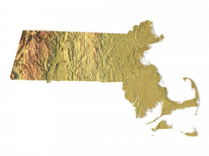
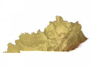
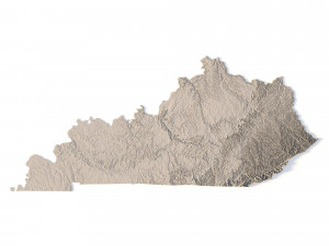
Create Detailed Kentucky Terrain Models with This High-Resolution 3D STL
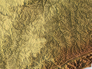
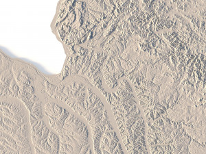
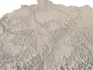
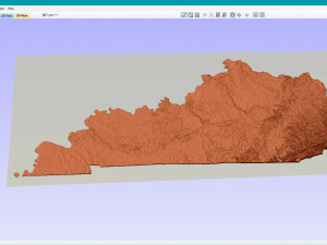
The Kentucky Topographic Map STL model offers a high-resolution depiction of the state’s topography and distinctive geographic features. This 3D model is perfect for crafting physical relief maps from materials such as wood, metal, plastic, or concrete. Whether used for landform visualization, educational purposes, or professional GIS projects, this model provides precise elevation data for accurate terrain modeling. Suitable for 3D printing, CNC machining, and laser engraving.
- File size: 704 MB / 506 MB
- Model size: 338.58 mm x 148.74 mm x 1.628 mm
- Resolution: 0,06 mm
- Projection: Mercator
- Scaling factor: X — 1; Y — 1; Z — 3
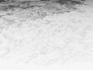
- Polygons: 14 778 224
- Vertices: 7 399 968
- Geometry: Polygonal Tris only
- Base: Open / Closed
Features of the Kentucky Topographic STL Model
Detailed elevation data capturing Kentucky’s hills, valleys, and diverse landforms.
Compatible with FDM/SLA 3D printers for creating detailed terrain models.
Designed for CNC machining to craft topographic maps from wood or metal.
Supports high-precision laser engraving for metal surface detailing.
Perlu lebih banyak format?
Jika Anda membutuhkan format yang berbeda, silakan buka Tiket Dukungan baru dan minta itu. Kita dapat mengonversi model 3D menjadi: .stl, .c4d, .obj, .fbx, .ma/.mb, .3ds, .3dm, .dxf/.dwg, .max. .blend, .skp, .glb. Konversi Format GratisKami tidak mengonversi adegan 3d dan format seperti .step, .iges, .stp, .sldprt.!
Informasi Penggunaan
Model STL Peta Topografi Kentucky - Anda dapat menggunakan model 3D bebas royalti ini untuk keperluan pribadi dan komersial sesuai dengan Lisensi Dasar atau Diperpanjang.Lisensi Dasar mencakup sebagian besar kasus penggunaan standar, termasuk iklan digital, proyek desain dan visualisasi, akun media sosial bisnis, aplikasi asli, aplikasi web, permainan video, dan produk akhir fisik atau digital (baik gratis maupun berbayar).
Lisensi Diperpanjang mencakup semua hak yang diberikan berdasarkan Lisensi Dasar, tanpa batasan penggunaan, dan memungkinkan model 3D untuk digunakan dalam proyek komersial tanpa batas dengan ketentuan Bebas Royalti.
Baca lebih lanjut