English
 Español
 Deutsch
 日本語
日本語 Polska
 Français
 中國
中國 한국의
한국의 Українська
 Italiano
 Nederlands
 Türkçe
 Português
 Bahasa Indonesia
 Русский
 हिंदी
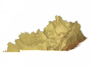
हिंदी켄터키 지형도 STL 모델 3D 프린트 모델

- 작성자에게 제품 지원 요청

- 이용 가능한 포맷:
- 아이템 ID:402305
- 날짜: 2022-06-17
- 컬렉션:No
- 밀리미터 폭:339
- 밀리미터 넓이:1.6
- 밀리미터 깊이:149
- 프린트 준비:
- 3D 스캔:No
- 성인용 콘텐츠:No
- PBR:No
- AI 훈련:No
- 조회:2318
설명
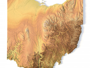
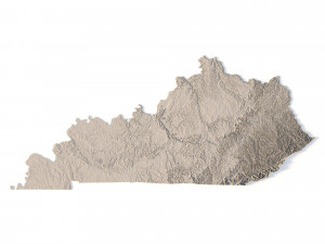
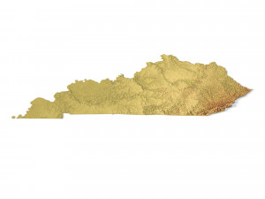
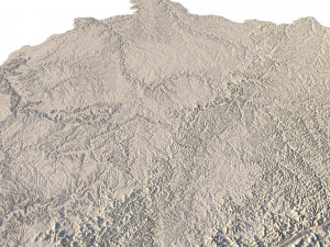
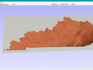
Create Detailed Kentucky Terrain Models with This High-Resolution 3D STL
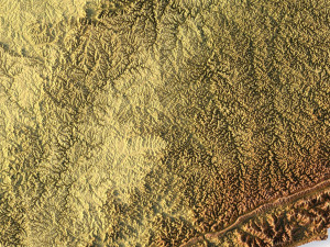
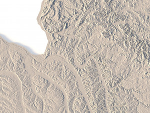
The Kentucky Topographic Map STL model offers a high-resolution depiction of the state’s topography and distinctive geographic features. This 3D model is perfect for crafting physical relief maps from materials such as wood, metal, plastic, or concrete. Whether used for landform visualization, educational purposes, or professional GIS projects, this model provides precise elevation data for accurate terrain modeling. Suitable for 3D printing, CNC machining, and laser engraving.
- File size: 704 MB / 506 MB
- Model size: 338.58 mm x 148.74 mm x 1.628 mm
- Resolution: 0,06 mm
- Projection: Mercator
- Scaling factor: X — 1; Y — 1; Z — 3
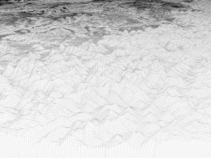
- Polygons: 14 778 224
- Vertices: 7 399 968
- Geometry: Polygonal Tris only
- Base: Open / Closed
Features of the Kentucky Topographic STL Model
Detailed elevation data capturing Kentucky’s hills, valleys, and diverse landforms.
Compatible with FDM/SLA 3D printers for creating detailed terrain models.
Designed for CNC machining to craft topographic maps from wood or metal.
Supports high-precision laser engraving for metal surface detailing.
다른 포맷이 필요하세요?
다른 포맷이 필요하시면, 새로운 지원 티켓을 열어 요청하세요. 저희는 3D 모델을 다음으로 변환할 수 있습니다: .stl, .c4d, .obj, .fbx, .ma/.mb, .3ds, .3dm, .dxf/.dwg, .max. .blend, .skp, .glb. 자유 형식 변환우리는 3D 장면을 변환하지 않습니다 .step, .iges, .stp, .sldprt와 같은 형식도 포함됩니다.!
사용 정보
켄터키 지형도 STL 모델 - 기본 또는 확장 라이선스에 따라 이 로열티 프리 3D 모델을 개인적 및 상업적 목적으로 사용할 수 있습니다.기본 라이선스는 디지털 광고, 디자인 및 시각화 프로젝트, 비즈니스 소셜 미디어 계정, 네이티브 앱, 웹 앱, 비디오 게임, 그리고 물리적 또는 디지털 최종 제품(무료 및 유료 모두)을 포함한 대부분의 표준 사용 사례를 포괄합니다.
확장 라이선스는 기본 라이선스에 따라 부여된 모든 권리를 포함하며 사용 제한이 없으며, 로열티 프리 조건 하에 3D 모델을 상업적 프로젝트에 무제한으로 사용할 수 있습니다.
더 보기