English
 Español
 Deutsch
 日本語
日本語 Polska
 Français
 中國
中國 한국의
한국의 Українська
 Italiano
 Nederlands
 Türkçe
 Português
 Bahasa Indonesia
 Русский
 हिंदी
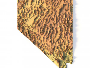
हिंदीमोंटाना स्थलाकृतिक मानचित्र एसटीएल मॉडल 3D प्रिंट मॉडल

- लेखक द्वारा उत्पाद समर्थन का अनुरोध करें

- उपलब्ध फ़ॉर्मेट्स:
- आइटम ID:402318
- तिथि: 2022-06-17
- कलेक्शन:No
- मिलीमीटर में चौड़ाई:534
- मिलीमीटर में ऊँचाई:4.8
- मिलीमीटर में गहराई:300
- प्रिंट के लिए तैयार:
- 3D स्कैन:No
- एडल्ट कंटेन्ट:No
- PBR:No
- एआई प्रशिक्षण:No
- व्यूस:3334
विवरण
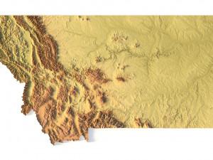
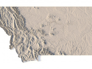
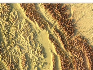
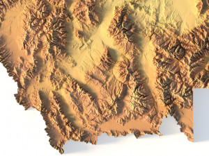
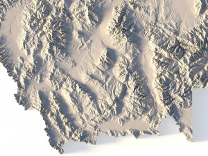
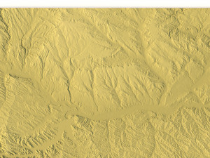
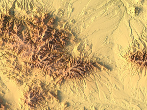
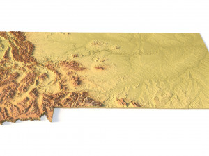
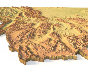
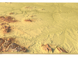
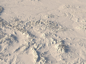
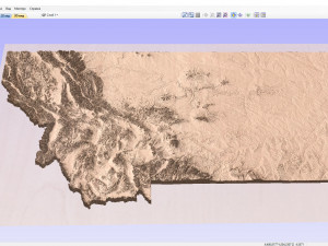
Create Detailed Montana Terrain Models with This High-Resolution 3D STL
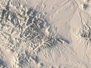
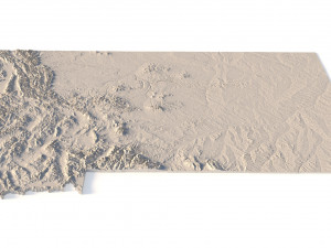
The Montana Topographic Map STL model provides a high-resolution representation of the state’s rugged topography and diverse geographic features. This 3D model is ideal for crafting physical relief maps from materials such as wood, metal, plastic, or concrete. Whether for landform visualization, educational projects, or professional GIS applications, this model delivers precise elevation data for accurate terrain modeling. Ideal for use with 3D printers, CNC machines, and laser engravers.
- File size: 1.21 GB / 623 MB
- Model size: 534.6 mm x 300.5 mm x 4.758 mm
- Resolution: 0.1 mm
- Projection: Mercator
- Datum: Google maps (sphere radius 6378137)
- EPSG code: 3857
- Scaling factor: X – 0.0000004; Y – 0.0000004; Z – 0.0000012
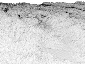
- Number of polygons: 26 181 818
- Number of vertices: 13 100 753
- Polygonal mesh: Triangles only
- Base: Open / Closed
Features of the Montana Topographic STL Model
Detailed elevation data showcasing Montana’s mountains, valleys, and plains.
Compatible with FDM/SLA 3D printers for creating high-quality terrain models.
Designed for CNC machining to craft relief maps from wood or metal.
Supports high-precision laser engraving for metal surface detailing.
क्या आपको और फ़ॉर्मेट्स चाहिए?
अगर आपको किसी अलग फ़ॉर्मेट की जरूरत है, तो कृपया हमें कन्वर्शन अनुरोध भेजें। हम 3D मॉडल को इसमें कन्वर्ट कर सकते हैं: .stl, .c4d, .obj, .fbx, .ma/.mb, .3ds, .3dm, .dxf/.dwg, .max. .blend, .skp, .glb. फ्री फ़ॉर्मेट कन्वर्शनहम 3D दृश्यों को कन्वर्ट नहीं करते हैं और .step, .uges, .stp, .sldprt जैसे प्रारूप।!
Usage Information
मोंटाना स्थलाकृतिक मानचित्र एसटीएल मॉडल - You can use this royalty-free 3D model for both personal and commercial purposes in accordance with the Basic or Extended License.The Basic License covers most standard use cases, including digital advertisements, design and visualization projects, business social media accounts, native apps, web apps, video games, and physical or digital end products (both free and sold).
The Extended License includes all rights granted under the Basic License, with no usage limitations, and allows the 3D model to be used in unlimited commercial projects under Royalty-Free terms.
और पढ़ें
क्या आप पैसे वापसी की गारंटी प्रदान करते हैं?
हां, हम करते हैं। अगर आपने कोई उत्पाद खरीदा है और रेंडर या विवरण में कुछ त्रुटि पाई है, तो हम समस्या को जल्द से जल्द ठीक करने का कोशिश करेंगे। अगर हम त्रुटि को ठीक नहीं कर सकते हैं, तो हम आपका ऑर्डर रद्द कर देंगे और आइटम डाउनलोड करने के 24 घंटों के भीतर आपको अपना पैसा वापस मिल जाएगा। और शर्तें यहां पढ़ेंकीवर्ड्स
लेखक से रैंडम आइटम्स