English
 Español
 Deutsch
 日本語
日本語 Polska
 Français
 中國
中國 한국의
한국의 Українська
 Italiano
 Nederlands
 Türkçe
 Português
 Bahasa Indonesia
 Русский
 हिंदी
हिंदीArkansas Topographic Map STL Models 3D Druckmodell

- Fordern Sie Produktunterstützung

- Verfügbare Formate:
- Artikel-ID:402079
- Datum: 2022-06-15
- Sammlung:No
- Breite in Millimeter:221
- Höhe in Millimeter:1.1
- Tiefe in Millimeter:188
- Druckfertige:No
- 3D Scan:No
- Erwachsene:No
- PBR:No
- KI-Training:No
- Betrachter:2487
Beschreibung
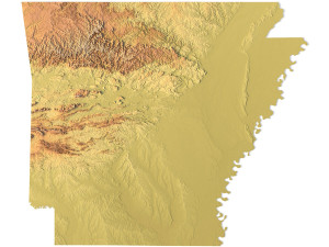
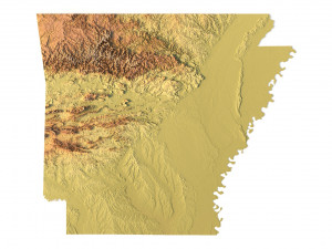
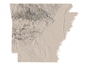
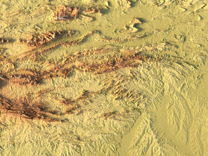
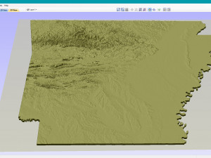
Create Detailed Arkansas Terrain Models with This High-Resolution 3D STL
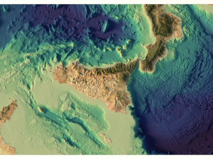
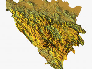
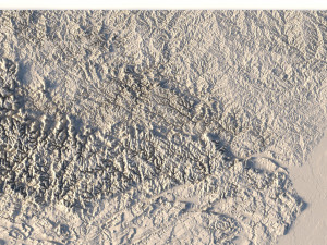
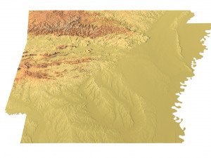
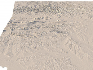
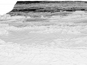
The Arkansas Topographic Map STL model provides a high-resolution representation of the state’s topography and geographic features. Perfect for creating physical relief maps from wood, metal, plastic, or concrete, this 3D model offers detailed accuracy for a variety of uses, including landform visualization, education, and professional GIS projects. Whether you’re using a 3D printer, CNC machine, or laser engraver, this model ensures precise terrain representation.
• Format: STL
• Files size: 867 MB / 450 MB
• Polygons: 18 1** 670
• Vertices: 9 104 309
• Geometry: Polygonal Tris only
• Model size: 221.34 mm x 1**.58 mm x 1.124 mm
• Distance between two neighboring vertices: ~ 0,06 mm
• Projection: Mercator
• Scaling factor X:Y:Z: 1:1:3
• Base: Open / Closed
Features of the Arkansas Topographic STL Model
• Detailed elevation data capturing Arkansas’ diverse landforms.
• Compatible with FDM/SLA 3D printers for creating accurate terrain models.
• Designed for CNC machining to craft wood or metal relief maps.
• Supports high-precision laser engraving for metal surface detailing.
Sie brauchen mehr Formate?
Falls Sie ein anderes Format benötigen, eröffnen Sie bitte ein neues Support-Ticket und fragen Sie danach. Wir können 3D Modelle in folgende Formate konvertieren: .stl, .c4d, .obj, .fbx, .ma/.mb, .3ds, .3dm, .dxf/.dwg, .max. .blend, .skp, .glb. Kostenlose FormatkonvertierungWir konvertieren keine 3D Szenen und Formate wie .step, .iges, .stp, .sldprt usw!
Nutzungsinformationen
Arkansas Topographic Map STL Models - Sie können dieses lizenzfreie 3D Modell gemäß der Basis- oder erweiterten Lizenz sowohl für private als auch für kommerzielle Zwecke verwenden.Die Basislizenz deckt die meisten Standardanwendungsfälle ab, darunter digitale Werbung, Design- und Visualisierungsprojekte, Social-Media-Konten von Unternehmen, native Apps, Web-Apps, Videospiele sowie physische oder digitale Endprodukte (sowohl kostenlos als auch kostenpflichtig).
Die Erweiterte Lizenz umfasst alle unter der Basislizenz gewährten Rechte ohne Nutzungsbeschränkungen und ermöglicht die Verwendung des 3D Modells in unbegrenzten kommerziellen Projekten unter Lizenzgebührenfreiheit.
Mehr lesen
Bieten Sie eine Geld-zurück-Garantie?
Ja, tun wir. Wenn Sie ein Produkt erworben haben und einen Fehler in den Rendern oder der Beschreibung finden, werden wir versuchen das Problem so bad wie möglich zu beheben. Wenn wir den Fehler nicht beheben können, stornieren wir Ihre Bestellung und Sie bekommen Ihr Geld innerhalb von 24 Stunden nach dem Download des Artikels zurück. . Lesen Sie weitere Bedingungen hierStichworte
Zufällige Artikel des Autors