English
 Español
 Deutsch
 日本語
日本語 Polska
 Français
 中國
中國 한국의
한국의 Українська
 Italiano
 Nederlands
 Türkçe
 Português
 Bahasa Indonesia
 Русский
 हिंदी
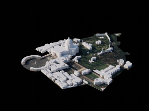
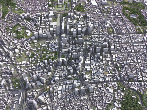
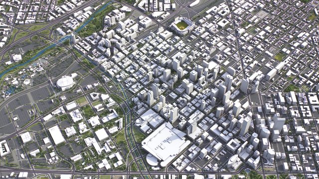
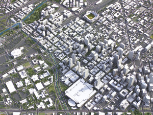
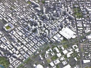
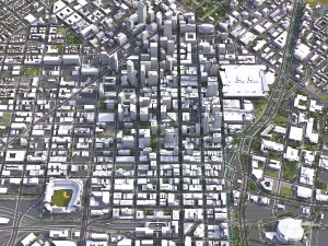
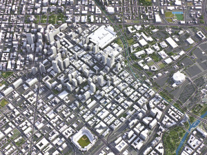
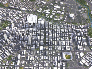
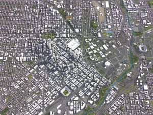
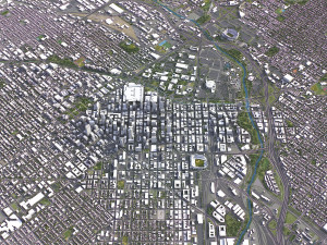
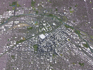
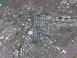
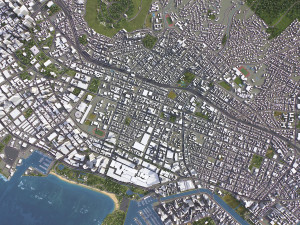
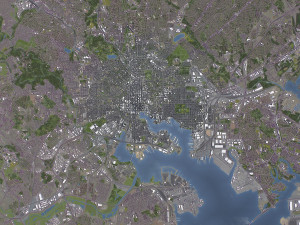
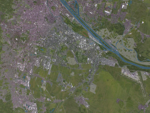
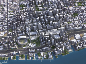
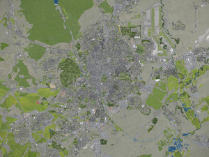
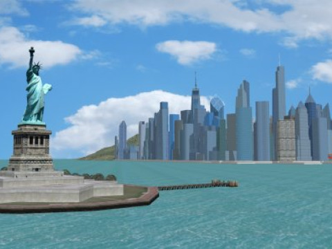
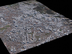
हिंदीDenver - 3D City Model Low-poly 3D Modell


HALLOWEEN
1 DAY SALE 50% OFF
$
399.00 USD
Sie haben $0.00 Credits. Credits kaufen

- Verfügbare Formate: Autodesk 3DS MAX (.max) 60.95 MB
- Polygone:1
- Eckpunkte:1
- Animiert:
- Texturen:
- Rigged:No
- Materialien:
- Low-poly:
- Sammlung:No
- UVW mapping:
- Plugins Used:No
- Druckfertige:No
- 3D Scan:No
- Erwachsene:No
- PBR:
- KI-Training:
- Geometrie:Polygonal
- Unwrapped UVs:No
- Betrachter:1365
- Datum: 2024-01-22
- Artikel-ID:488230
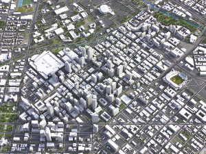
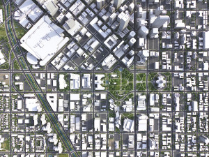
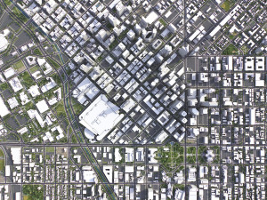
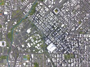
Denver - 3D City Model 3D Modell max, Von 3d.city.models
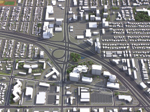
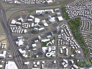
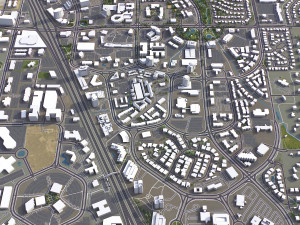
TOP-QUALITY 3D CITY MODEL - 2024 UPDATE- Message us to get a FREE sample scene of this product!
- Download an overview sample - https://each.city/sample
- 24/7 customer support — customization, flexible pricing and exclusive discounts
WHAT IS INCLUDED
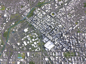
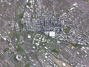
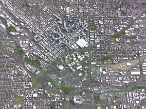
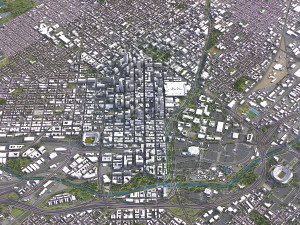
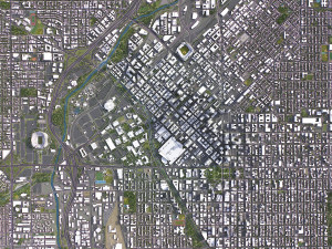
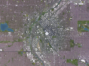
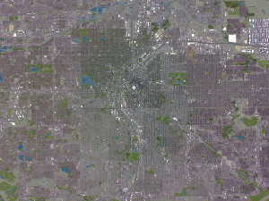
- Scene size: Entire area — refer to promo images for scene extents
- Units: Meters — real-world scale
- Updated: January 2024 — want the latest? Ask before you pay
KEY BENEFITS
- 24/7 customer support — reach out to us anytime for pre-sale inquiries or after-sale support
- Extensive file format support — 3ds Max (native), fbx, obj, dae, c4d, skp, 3dm, rvt, blend, etc., or ask for more before payment
- Georeferencing — either Web Mercator, Trаnsverse Mercator, or original CRS. If a specific CRS is essential, ask before you pay
- Any scene size or crop to an area-of-interest — for best performance and format compatibility, inquire before paying
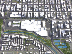
- Buildings, land-use areas, roads and railways split by type — layers / named objects
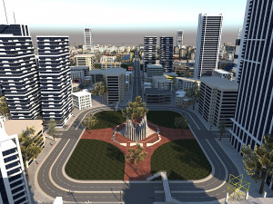
- Detailed landmarks with regular updates and improvements — available annually or upon pre-purchase inquiry
- Realistic and detailed surface texture — 1-meter resolution satellite imagery
- Flat surface, easy for detailing and geometry edits — topography terrain available at an additional cost. Message us for a quote
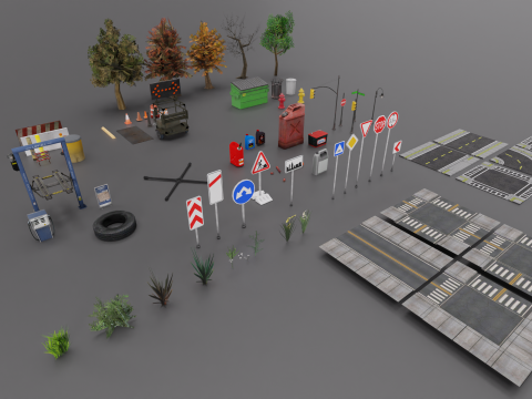
- Realistic low-poly vegetation — individual trees in max and fbx formats, additional formats upon request before you pay
- Product is ready to render out-of-the-box — 3ds Max + Corona Render
PRESENTATION IMAGES & MATERIALS
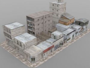
- 4K high-resolution renders — refer to images for level of detail and scene size
- Produced in 3ds Max — other software requires its rendering settings
- Trees, vegetation, land-use and airport surface with the textures assigned
- Buildings are UV mapped, split by material IDs, and no textures assigned
CUSTOMIZE & SAVE
- Message us to get a fully customizable model based on the options listed below
- Fast turnaround, flexible pricing and discounts
DATA AUTHENTICITY
- 100% real buildings coverage — unlike other sellers, we don’t use AI generated building footprints
- Combining multiple sources — you may provide us with any dataset to include in the model
GEOREFERENCING and GEOLOCATION - allows you to precisely position 3D content
- Web Mercator / WGS 84 — specified by true scale latitude
- Trаnsverse Mercator — defined by central meridian
- Original CRS — local or optimal for this area
TOPOGRAPHY TERRAIN
- Up to 1-meter accuracy digital terrain model (DTM) — quad mesh
- Multiple terrain LODs — triangle mesh optimized for the best polycount / details balance
- Buildings and roads placed on the optimized terrain
- Separate land surface and water bodies
- High-resolution satellite or surface texture — up to 0.2 meter accuracy
- Contour lines — 3D splines, up to 1-meter interval
MANUAL MODELING
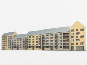
- Buildings and structures — LOD2 and LOD3
- Elevated highways — interchanges, bridges and flyovers
TEXTURING
- High-resolution surface texture — satellite image up to 0.2 meter accuracy
- Streets and roads with markings texture — UV mapped along the center line
- Procedural textures assigned to all buildings — LOD1 only
- Realistic textures on individual buildings — LOD2 and LOD3
TREES & FORESTS
- Individual trees — real trees from OSM data
- Procedural forests — based on distribution areas, convertible to individual trees
OTHER EXTRAS
- Individual buildings and streets — separate objects with address and/or name
- Administrative boundaries of all levels — named polygons or outlines
- Road and railway splines — for traffic animation, etc.
- Public trаnsport stops — individual named objects
FILE FORMATS
- max — Autodesk 3ds Max
- fbx, obj, dae, 3ds — Exchange Formats
- uproject, uasset — Unreal Engine
- glb, gltf — Games, Web, AR/VR
- unitypackage — Unity 3D
- 3dm — Rhino 3D
- skp — SketchUp
- rvt — Autodesk Revit
- c4d — Cinema4D
- blend — Blender
- ma, mb — Autodesk Maya
- dwg, dxf — Autodesk AutoCAD
- stl — 3D Print
Sie brauchen mehr Formate?
Falls Sie ein anderes Format benötigen, eröffnen Sie bitte ein neues Support-Ticket und fragen Sie danach. Wir können 3D Modelle in folgende Formate konvertieren: .stl, .c4d, .obj, .fbx, .ma/.mb, .3ds, .3dm, .dxf/.dwg, .max. .blend, .skp, .glb. Wir konvertieren keine 3D Szenen und Formate wie .step, .iges, .stp, .sldprt usw!Nutzungsinformationen
Denver - 3D City Model - Sie können dieses lizenzfreie 3D Modell gemäß der Basis- oder erweiterten Lizenz sowohl für private als auch für kommerzielle Zwecke verwenden.Die Basislizenz deckt die meisten Standardanwendungsfälle ab, darunter digitale Werbung, Design- und Visualisierungsprojekte, Social-Media-Konten von Unternehmen, native Apps, Web-Apps, Videospiele sowie physische oder digitale Endprodukte (sowohl kostenlos als auch kostenpflichtig).
Die Erweiterte Lizenz umfasst alle unter der Basislizenz gewährten Rechte ohne Nutzungsbeschränkungen und ermöglicht die Verwendung des 3D Modells in unbegrenzten kommerziellen Projekten unter Lizenzgebührenfreiheit.
Mehr lesen
Bieten Sie eine Geld-zurück-Garantie?
Ja, tun wir. Wenn Sie ein Produkt erworben haben und einen Fehler in den Rendern oder der Beschreibung finden, werden wir versuchen das Problem so bad wie möglich zu beheben. Wenn wir den Fehler nicht beheben können, stornieren wir Ihre Bestellung und Sie bekommen Ihr Geld innerhalb von 24 Stunden nach dem Download des Artikels zurück. . Lesen Sie weitere Bedingungen hierStichworte
city map model area building center skyline landscape topography downtown skyscraper airport urban street sketchup terrain elevation 3d detailed realisticEs gibt keine Kommentare zu diesem Artikel.
-50%
max blend c4d fbx mb2018 obj
lowpolylab
Cityscapes
$49.50
$99.00
-50%
fbx obj max2016 max2016 3ds dwg
Lycaena
Cityscapes
$124.50
$249.00