English
 Español
 Deutsch
 日本語
日本語 Polska
 Français
 中國
中國 한국의
한국의 Українська
 Italiano
 Nederlands
 Türkçe
 Português
 Bahasa Indonesia
 Русский
 हिंदी
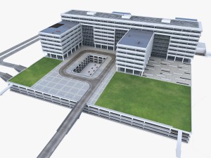
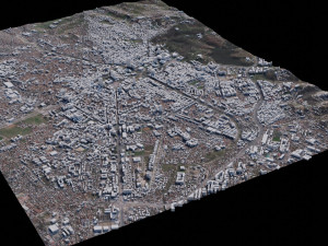
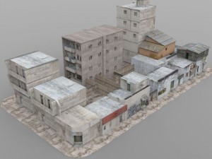
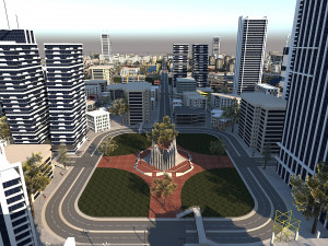
हिंदीMunich - 3D City Model Low-poly Model 3D


$
399.00 USD
Musisz $0.00 Kredyty. Kup kredyty

- Dostępne formaty: Autodesk 3DS MAX (.max) 194.62 MB
- Wielokąty:1
- Wierzchołki:1
- Model animowany:
- Tekstury:
- Oparty na szkielecie:No
- Materiał:
- Low-poly:
- Kolekcja:No
- UVW mapping:
- Plugins Used:No
- Gotowy do wydruku:No
- 3D Scan:No
- Adult content:No
- PBR:
- AI Szkolenie:
- Geometria:Polygonal
- Unwrapped UVs:No
- Liczba wyświetleń:1489
- Data: 2024-01-22
- ID produktu:488267
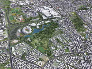
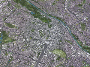
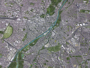
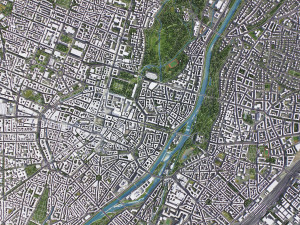
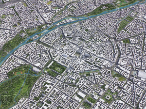
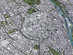
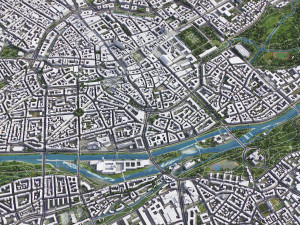
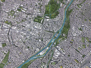
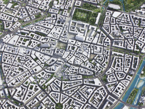
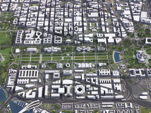
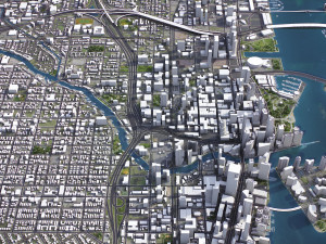
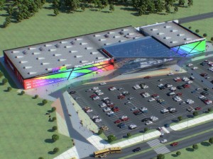
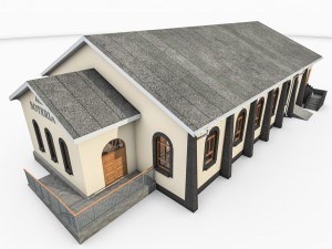
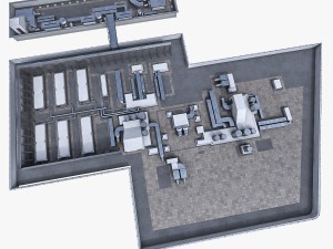
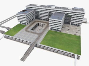
Munich - 3D City Model Model 3D max, Od 3d.city.models
TOP-QUALITY 3D CITY MODEL - 2024 UPDATE- Message us to get a FREE sample scene of this product!
- Download an overview sample - https://each.city/sample
- 24/7 customer support — customization, flexible pricing and exclusive discounts
WHAT IS INCLUDED
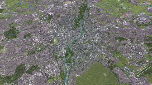
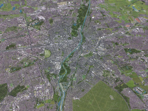
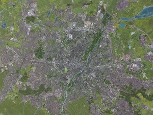
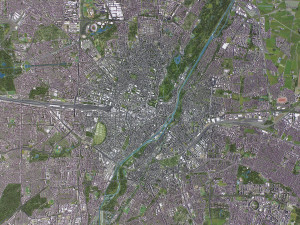
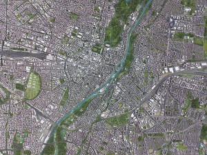
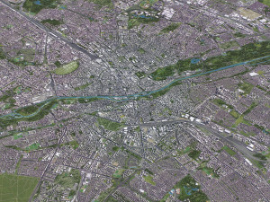
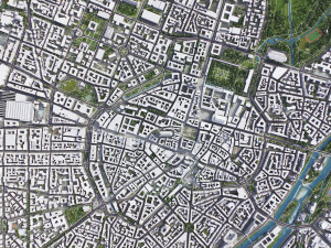
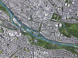
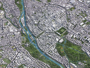
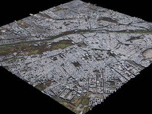
- Scene size: Entire area — refer to promo images for scene extents
- Units: Meters — real-world scale
- Updated: January 2024 — want the latest? Ask before you pay
KEY BENEFITS
- 24/7 customer support — reach out to us anytime for pre-sale inquiries or after-sale support
- Extensive file format support — 3ds Max (native), fbx, obj, dae, c4d, skp, 3dm, rvt, blend, etc., or ask for more before payment
- Georeferencing — either Web Mercator, Trаnsverse Mercator, or original CRS. If a specific CRS is essential, ask before you pay
- Any scene size or crop to an area-of-interest — for best performance and format compatibility, inquire before paying
- Buildings, land-use areas, roads and railways split by type — layers / named objects
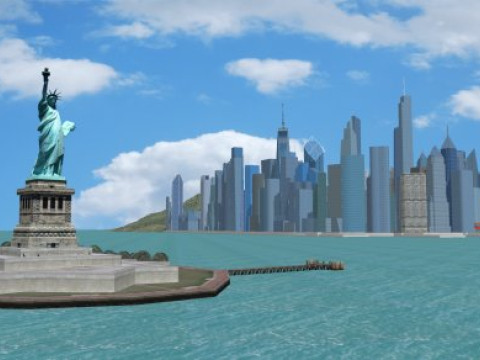
- Detailed landmarks with regular updates and improvements — available annually or upon pre-purchase inquiry
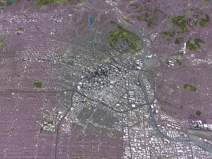
- Realistic and detailed surface texture — 1-meter resolution satellite imagery
- Flat surface, easy for detailing and geometry edits — topography terrain available at an additional cost. Message us for a quote
- Realistic low-poly vegetation — individual trees in max and fbx formats, additional formats upon request before you pay
- Product is ready to render out-of-the-box — 3ds Max + Corona Render
PRESENTATION IMAGES & MATERIALS
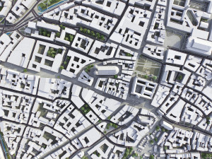
- 4K high-resolution renders — refer to images for level of detail and scene size
- Produced in 3ds Max — other software requires its rendering settings
- Trees, vegetation, land-use and airport surface with the textures assigned
- Buildings are UV mapped, split by material IDs, and no textures assigned
CUSTOMIZE & SAVE
- Message us to get a fully customizable model based on the options listed below
- Fast turnaround, flexible pricing and discounts
DATA AUTHENTICITY
- 100% real buildings coverage — unlike other sellers, we don’t use AI generated building footprints
- Combining multiple sources — you may provide us with any dataset to include in the model
GEOREFERENCING and GEOLOCATION - allows you to precisely position 3D content
- Web Mercator / WGS 84 — specified by true scale latitude
- Trаnsverse Mercator — defined by central meridian
- Original CRS — local or optimal for this area
TOPOGRAPHY TERRAIN
- Up to 1-meter accuracy digital terrain model (DTM) — quad mesh
- Multiple terrain LODs — triangle mesh optimized for the best polycount / details balance
- Buildings and roads placed on the optimized terrain
- Separate land surface and water bodies
- High-resolution satellite or surface texture — up to 0.2 meter accuracy
- Contour lines — 3D splines, up to 1-meter interval
MANUAL MODELING
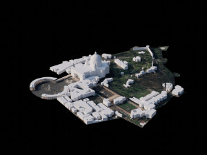
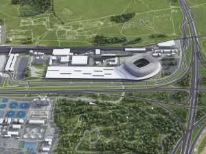
- Buildings and structures — LOD2 and LOD3
- Elevated highways — interchanges, bridges and flyovers
TEXTURING
- High-resolution surface texture — satellite image up to 0.2 meter accuracy
- Streets and roads with markings texture — UV mapped along the center line
- Procedural textures assigned to all buildings — LOD1 only
- Realistic textures on individual buildings — LOD2 and LOD3
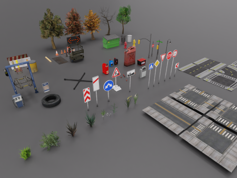
TREES & FORESTS
- Individual trees — real trees from OSM data
- Procedural forests — based on distribution areas, convertible to individual trees
OTHER EXTRAS
- Individual buildings and streets — separate objects with address and/or name
- Administrative boundaries of all levels — named polygons or outlines
- Road and railway splines — for traffic animation, etc.
- Public trаnsport stops — individual named objects
FILE FORMATS
- max — Autodesk 3ds Max
- fbx, obj, dae, 3ds — Exchange Formats
- uproject, uasset — Unreal Engine
- glb, gltf — Games, Web, AR/VR
- unitypackage — Unity 3D
- 3dm — Rhino 3D
- skp — SketchUp
- rvt — Autodesk Revit
- c4d — Cinema4D
- blend — Blender
- ma, mb — Autodesk Maya
- dwg, dxf — Autodesk AutoCAD
- stl — 3D Print
Potrzebujesz plik w innym formacie?
Jeśli potrzebny Ci plik w innym formacie, zgłoś taką potrzebę przez opcję Support Ticket Konwertujemy produkty na następujące formaty: .stl, .c4d, .obj, .fbx, .ma/.mb, .3ds, .3dm, .dxf/.dwg, .max. .blend, .skp, .glb. Nie konwertujemy scen 3D oraz formaty takie jak .step, .iges, .stp, .sldprt.!Informacje o użytkowaniu
Munich - 3D City Model - Możesz używać tego bezpłatnego modelu 3D zarówno do celów osobistych, jak i komercyjnych, zgodnie z Licencją Podstawową lub Rozszerzoną.Licencja Podstawowa obejmuje większość standardowych przypadków użycia, w tym reklamy cyfrowe, projekty projektowe i wizualizacyjne, firmowe konta w mediach społecznościowych, aplikacje natywne, aplikacje internetowe, gry wideo oraz fizyczne lub cyfrowe produkty końcowe (zarówno bezpłatne, jak i sprzedawane).
Licencja Rozszerzona obejmuje wszystkie prawa udzielone na mocy Licencji Podstawowej, bez ograniczeń użytkowania i pozwala na wykorzystanie modelu 3D w nieograniczonej liczbie projektów komercyjnych na warunkach bezpłatności.
Czytaj więcej
Czy zapewniacie gwarancję zwrotu pieniędzy?
Tak, robimy to. Jeśli zakupiłeś produkt i znalazłeś błąd w renderach lub opisie, postaramy się rozwiązać problem tak szybko, jak to możliwe. Jeżeli nie uda nam się naprawić błędu, anulujemy Twoje zamówienie i otrzymasz zwrot pieniędzy w ciągu 24 godzin od pobrania przedmiotu. Przeczytaj więcej warunków tutajSłowa kluczowe
Brak komentarzy dla tego produktu.
fbx obj max2016 max2016 3ds dwg
Lycaena
Cityscapes