English
 Español
 Deutsch
 日本語
日本語 Polska
 Français
 中國
中國 한국의
한국의 Українська
 Italiano
 Nederlands
 Türkçe
 Português
 Bahasa Indonesia
 Русский
 हिंदी
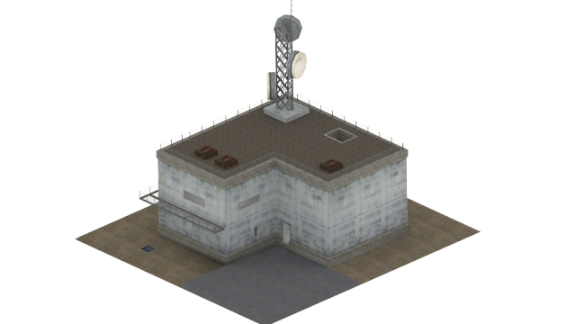
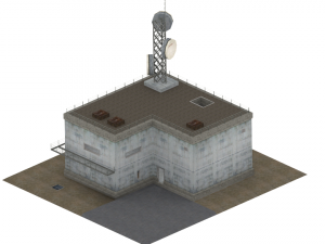
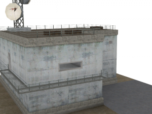
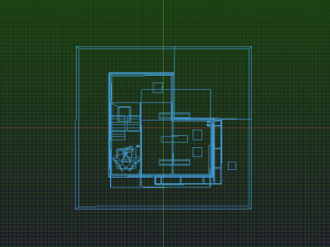
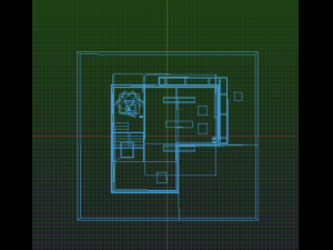
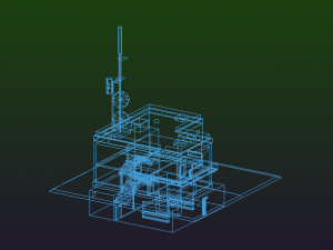
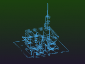
हिंदीCostruzione del radar Low-poly Modello 3D


$
15.00 USD
onclick="showLoginForm('Login');return false; ga('send', {'hitType': 'event', 'eventCategory': 'ShoppingCart', 'eventAction': 'checkout', 'eventLabel': 'CheckoutCredit' });"> Acquistalo con Crediti
Tu hai $0.00 Crediti. Acquista Crediti
- Richiedi supporto per il prodotto

- Formati disponibili:
- ID Oggetto:478769
- Data: 2023-12-03
- Pligoni:686
- Vertici:2147
- Animato:No
- Textured:
- Rigged:No
- Materiali:
- Low-poly:
- Collezione:No
- Mapping UVW:
- Plugins Utilizzati:No
- Stampa Pronta:No
- 3D Scan:No
- Per adulti:No
- PBR:No
- Geometria:Polygonal
- UVs Aperti:Non-overlapping
- Visualizzazioni:1399
Descrizione
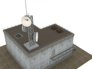
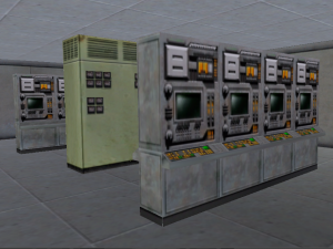
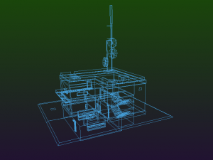
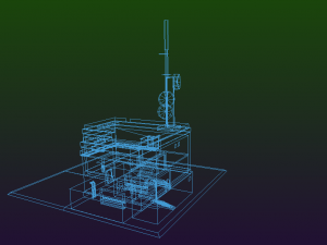
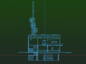
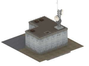
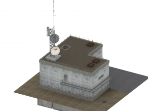
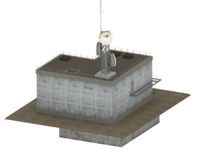
A radar tower is a tower whose function is to support a radar facility, usually a local airport surveillance radar, and hence often at or in the vicinity of an airport or a military air base. In addition, radar towers are used for the installation and operation of search and height finder radars at military radar stations where the mission is to support air defense missions. These missions were characterized as Aircraft Control & Warning (AC&W) or Long Range Surveillance in support of the Semi-automatic Ground Environment (SAGE).The tower typically has a continuously rotating parabolic antenna. Often the antenna is protected from the weather by a radome and is thus not visible from the outside.
For regional air traffic control, en route radar installations are used; for example there are six of these in Germany, erected at selected sites. The data from these radars is fed into the civilian RADNET system and transferred to all civil and military control centres.
Ideally a radar tower is built on a high spot in the terrain, because this reduces the angle of elevation and thus increases the range of the radar device. In the absence of a suitable high spot, radar towers are used. Radar towers are also need to provide weather protection and services (air conditioning and power) for the radar equipment, communications, operators and maintainers
In Germany the operational command posts of the German Air Force use the Bundeswehr radar towers for the stationary radar sites of the operational command areas.
Military radar stations have supported US and allied air defense operations at numerous worldwide locations since World War II. The largest network of military radar stations evolved during the Cold War era to support the air defense of North America as part of the joint US and Canadian command known as the North American Air Defense Command (NORAD). This military radar network became automated in 1960 with the operation of SAGE. SAGE provided the vital command, control, communications, and computers (C4S). Long Range Radar (LRR) stations were electronically connected to SAGE Direction Centers (DCs). This resulted in an integrated air defense system made up of radar, radio, interceptor aircraft, antiaircraft guns and missiles, and command and control (C2) facilities. Most of the radar and radio facilities were not on a military air base, but smaller Air Force Stations (AFS) usually located in rural and often isolated locations often miles away from even small towns. They were manned by up to several hundred Air Force personnel. An online radar museum provides descriptions of military radar stations at radomes.org/museum. Photographs of radar towers and radomes are provided. This includes the AN/FPS-24 search radar tower in a huge 64 foot square, 85 foot tall, five story building. On top of this radar tower was a radar antenna 50 feet tall, 120 feet wide, weighing 85.5 tons and rotating at 5 rpm. An available rigid radome 140 feet in diameter and 96 feet high protected this antenna from adverse weather conditions. Stampa Pronta: No
Hai bisogno di ulteriori formati?
Se hai bisogno di diversi formati, aprire un nuovo Ticket i Supporto e una richiesta per questo. Convertiamo modelli 3D a: .stl, .c4d, .obj, .fbx, .ma/.mb, .3ds, .3dm, .dxf/.dwg, .max. .blend, .skp, .glb. Conversione di formato gratuitaNon convertiamo scene 3d e formati come .step, .iges, .stp, .sldprt.!
Informazioni sull'utilizzo
Costruzione del radar - È possibile utilizzare questo modello 3D royalty-free sia per scopi personali che commerciali, in conformità con la licenza base o estesa.La licenza base copre la maggior parte dei casi d'uso standard, tra cui pubblicità digitale, progetti di design e visualizzazione, account aziendali sui social media, app native, app web, videogiochi e prodotti finali fisici o digitali (sia gratuiti che venduti).
La licenza estesa include tutti i diritti concessi dalla licenza base, senza limitazioni d'uso, e consente l'utilizzo del modello 3D in un numero illimitato di progetti commerciali secondo i termini royalty-free.
Leggi ulteriori
Offrite la garanzia di rimborso?
Sì, la offriamo. Se hai acquistato un prodotto e hai riscontrato degli errori nei renders o nella descrizione, proveremo a risolvere al più presto il problema. Se non possiamo correggere l'errore, annulleremo l'ordine e ti restituiremo i soldi entro 24 ore dal download dell'oggetto. Leggi le condizioni quiParole chiave
Oggetti casuali dall'autore


Nessun commento per quest'oggetto.