English
 Español
 Deutsch
 日本語
日本語 Polska
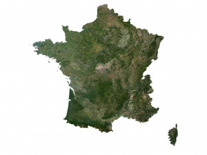
 Français
 中國
中國 한국의
한국의 Українська
 Italiano
 Nederlands
 Türkçe
 Português
 Bahasa Indonesia
 Русский
 हिंदी
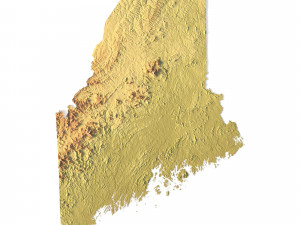
हिंदीModello STL della mappa topografica del Connecticut Modello di stampa 3D


- Richiedi supporto per il prodotto

- Formati disponibili:
- ID Oggetto:402260
- Data: 2022-06-17
- Collezione:No
- Larghezza in millimetri:86
- Altezza in millimetri:1
- Profondità in millimetri:63
- Stampa Pronta:No
- 3D Scan:No
- Per adulti:No
- PBR:No
- AI Formazione:No
- Visualizzazioni:2290
Descrizione
Create Detailed Colorado Terrain Models with This 3D STL
The Colorado Map Topographic STL model provides highly detailed terrain models of the state’s iconic landscape. Ideal for creating raised relief maps from materials like wood, metal, plastic, or concrete, this STL file is perfect for professionals and hobbyists interested in outdoor recreation, geospatial analysis, or landscape visualization. Whether for personal use or professional applications, this model brings the state’s varied landforms to life with precision elevation data.
- File size: 390 MB
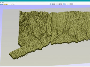
- Model size: 86.34 mm x 63.24 mm x 0.995 mm
- Projection: Mercator
- Scaling factor: X — 1; Y — 1; Z — 3
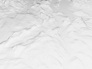
- Polygons: 8 185 972
- Vertices: 4 104 970
- Geometry: Polygonal Tris only
- Base: Closed
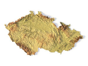
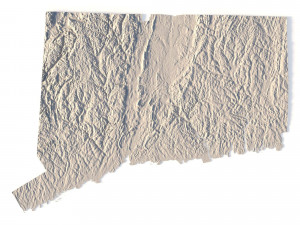
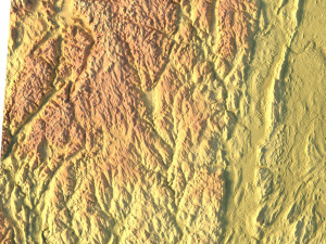
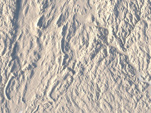
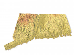
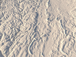
Create Detailed Connecticut Terrain Models with This 3D STL
The Connecticut Topographic Map STL model provides precise topography of Connecticut’s landscape. This 3D model is perfect for creating raised relief maps using materials such as wood, metal, plastic, or concrete. Whether for personal projects or professional terrain visualization, this model offers accurate geospatial data for a wide range of applications, including landscape visualization, educational models, and more.
Stampa Pronta: NoHai bisogno di ulteriori formati?
Se hai bisogno di diversi formati, aprire un nuovo Ticket i Supporto e una richiesta per questo. Convertiamo modelli 3D a: .stl, .c4d, .obj, .fbx, .ma/.mb, .3ds, .3dm, .dxf/.dwg, .max. .blend, .skp, .glb. Conversione di formato gratuitaNon convertiamo scene 3d e formati come .step, .iges, .stp, .sldprt.!
Informazioni sull'utilizzo
Modello STL della mappa topografica del Connecticut - È possibile utilizzare questo modello 3D royalty-free sia per scopi personali che commerciali, in conformità con la licenza base o estesa.La licenza base copre la maggior parte dei casi d'uso standard, tra cui pubblicità digitale, progetti di design e visualizzazione, account aziendali sui social media, app native, app web, videogiochi e prodotti finali fisici o digitali (sia gratuiti che venduti).
La licenza estesa include tutti i diritti concessi dalla licenza base, senza limitazioni d'uso, e consente l'utilizzo del modello 3D in un numero illimitato di progetti commerciali secondo i termini royalty-free.
Leggi ulteriori
Offrite la garanzia di rimborso?
Sì, la offriamo. Se hai acquistato un prodotto e hai riscontrato degli errori nei renders o nella descrizione, proveremo a risolvere al più presto il problema. Se non possiamo correggere l'errore, annulleremo l'ordine e ti restituiremo i soldi entro 24 ore dal download dell'oggetto. Leggi le condizioni quiParole chiave
Oggetti casuali dall'autore
Mostra tutti gli oggetti di sychev23021983