English
 Español
 Deutsch
 日本語
日本語 Polska
 Français
 中國
中國 한국의
한국의 Українська
 Italiano
 Nederlands
 Türkçe
 Português
 Bahasa Indonesia
 Русский
 हिंदी
हिंदीジェッダ - 3D 都市モデル 低ポリ 3Dモデル

BLACK FRIDAY
Early Access 50% OFF
$
399.00 USD
onclick="showLoginForm('Login');return false; ga('send', {'hitType': 'event', 'eventCategory': 'ShoppingCart', 'eventAction': 'checkout', 'eventLabel': 'CheckoutCredit' });"> で買う クレジット
を持っています $0.00 クレジット. クレジットを購入する
- 作者による製品サポートのリクエスト

- 利用可能フォーマット:
- アイテム ID:488442
- 日付: 2024-01-23
- 多角形:1
- 頂点:1
- アニメーション:
- テクスチャー加工:
- 装飾:No
- 素材:
- 低ポリ:
- コレクション:No
- UVW マッピング:
- 使用中プラグイン:No
- 印刷 準備:No
- 3D スキャン:No
- 成人コンテンツ:No
- PBR:
- AIトレーニング:
- ジオメトリ:Polygonal
- 展開済 UVs:No
- ビュー:1530
説明
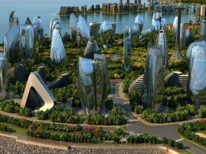
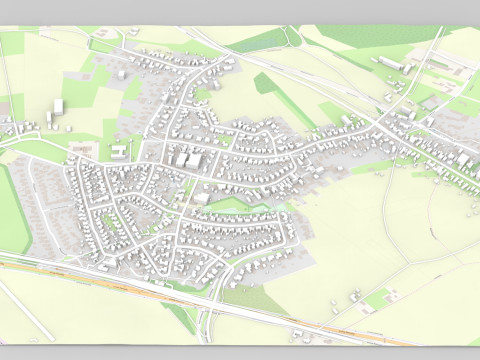
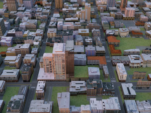
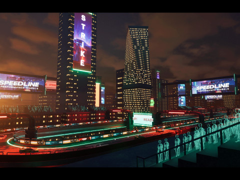
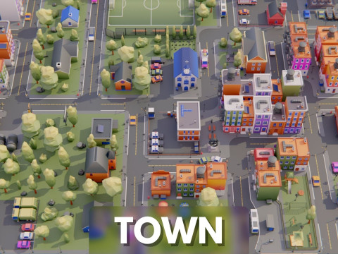
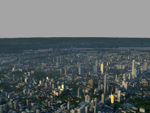
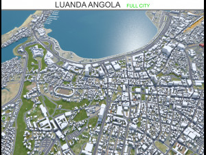
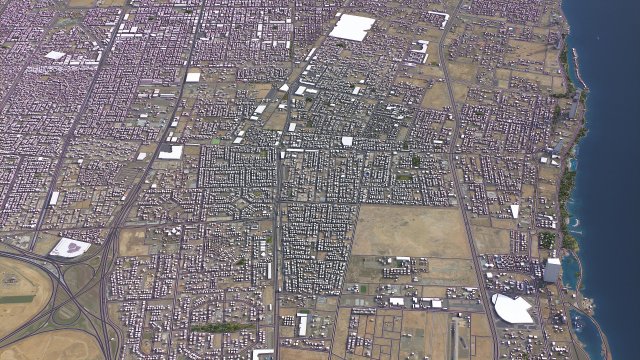
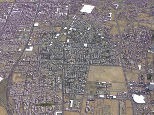
TOP-QUALITY 3D CITY MODEL - 2024 UPDATE- Message us to get a FREE sample scene of this product!
- Download an overview sample - https://each.city/sample
- 24/7 customer support — customization, flexible pricing and exclusive discounts
WHAT IS INCLUDED
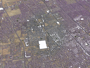
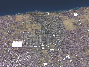
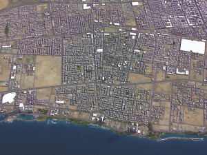
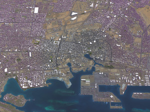
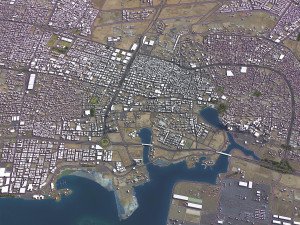
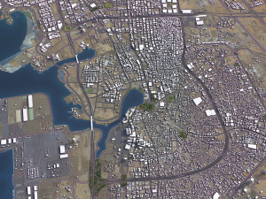
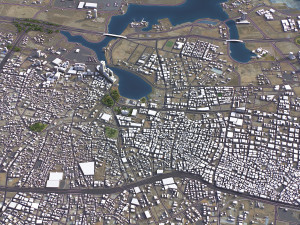
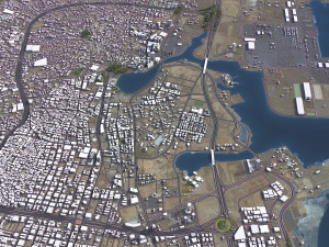
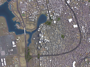
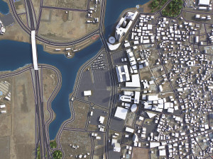
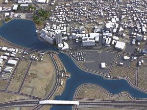
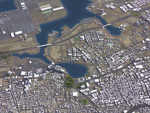
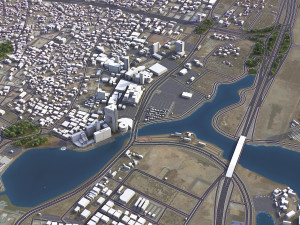
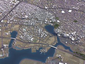
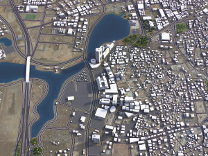
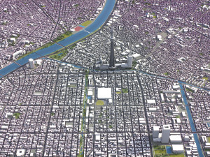
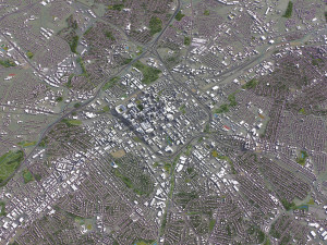
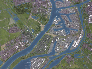
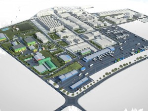
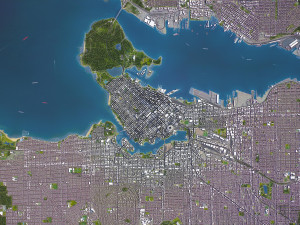
- Scene size: Entire area — refer to promo images for scene extents
- Units: Meters — real-world scale
- Updated: January 2024 — want the latest? Ask before you pay
KEY BENEFITS
- 24/7 customer support — reach out to us anytime for pre-sale inquiries or after-sale support
- Extensive file format support — 3ds Max (native), fbx, obj, dae, c4d, skp, 3dm, rvt, blend, etc., or ask for more before payment
- Georeferencing — either Web Mercator, Trаnsverse Mercator, or original CRS. If a specific CRS is essential, ask before you pay
- Any scene size or crop to an area-of-interest — for best performance and format compatibility, inquire before paying
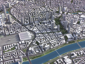
- Buildings, land-use areas, roads and railways split by type — layers / named objects
- Detailed landmarks with regular updates and improvements — available annually or upon pre-purchase inquiry
- Realistic and detailed surface texture — 1-meter resolution satellite imagery
- Flat surface, easy for detailing and geometry edits — topography terrain available at an additional cost. Message us for a quote
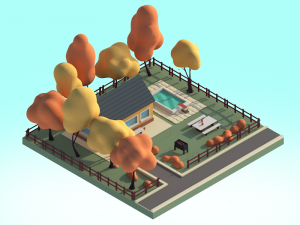
- Realistic low-poly vegetation — individual trees in max and fbx formats, additional formats upon request before you pay
- Product is ready to render out-of-the-box — 3ds Max + Corona Render
PRESENTATION IMAGES & MATERIALS
- 4K high-resolution renders — refer to images for level of detail and scene size
- Produced in 3ds Max — other software requires its rendering settings
- Trees, vegetation, land-use and airport surface with the textures assigned
- Buildings are UV mapped, split by material IDs, and no textures assigned
CUSTOMIZE & SAVE
- Message us to get a fully customizable model based on the options listed below
- Fast turnaround, flexible pricing and discounts
DATA AUTHENTICITY
- 100% real buildings coverage — unlike other sellers, we don’t use AI generated building footprints
- Combining multiple sources — you may provide us with any dataset to include in the model
GEOREFERENCING and GEOLOCATION - allows you to precisely position 3D content
- Web Mercator / WGS 84 — specified by true scale latitude
- Trаnsverse Mercator — defined by central meridian
- Original CRS — local or optimal for this area
TOPOGRAPHY TERRAIN
- Up to 1-meter accuracy digital terrain model (DTM) — quad mesh
- Multiple terrain LODs — triangle mesh optimized for the best polycount / details balance
- Buildings and roads placed on the optimized terrain
- Separate land surface and water bodies
- High-resolution satellite or surface texture — up to 0.2 meter accuracy
- Contour lines — 3D splines, up to 1-meter interval
MANUAL MODELING
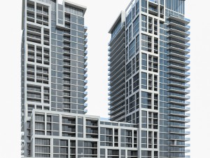
- Buildings and structures — LOD2 and LOD3
- Elevated highways — interchanges, bridges and flyovers
TEXTURING
- High-resolution surface texture — satellite image up to 0.2 meter accuracy
- Streets and roads with markings texture — UV mapped along the center line
- Procedural textures assigned to all buildings — LOD1 only
- Realistic textures on individual buildings — LOD2 and LOD3
TREES & FORESTS
- Individual trees — real trees from OSM data
- Procedural forests — based on distribution areas, convertible to individual trees
OTHER EXTRAS
- Individual buildings and streets — separate objects with address and/or name
- Administrative boundaries of all levels — named polygons or outlines
- Road and railway splines — for traffic animation, etc.
- Public trаnsport stops — individual named objects
FILE FORMATS
- max — Autodesk 3ds Max
- fbx, obj, dae, 3ds — Exchange Formats
- uproject, uasset — Unreal Engine
- glb, gltf — Games, Web, AR/VR
- unitypackage — Unity 3D
- 3dm — Rhino 3D
- skp — SketchUp
- rvt — Autodesk Revit
- c4d — Cinema4D
- blend — Blender
- ma, mb — Autodesk Maya
- dwg, dxf — Autodesk AutoCAD
- stl — 3D Print
フォーマットが必要ですか?
異なるフォーマットが必要な場合、サポートチケットを開き、注文をしてください。3Dモデルをこれらに変換できます: .stl, .c4d, .obj, .fbx, .ma/.mb, .3ds, .3dm, .dxf/.dwg, .max. .blend, .skp, .glb. フリーフォーマット変換3D シーンは変換しません .step、.iges、.stp、.sldprt などの形式。!
使用情報
ジェッダ - 3D 都市モデル - このロイヤリティフリーの3Dモデルは、基本ライセンスまたは拡張ライセンスに従って、個人および商用目的で使用できます。基本ライセンスは、デジタル広告、デザインおよび視覚化プロジェクト、ビジネスソーシャルメディアアカウント、ネイティブアプリ、ウェブアプリ、ビデオゲーム、物理またはデジタル最終製品(無料および有償)など、ほとんどの標準的な使用事例をカバーしています。
拡張ライセンスには、基本ライセンスで付与されるすべての権利が使用制限なしで含まれており、ロイヤリティフリーの条件の下で、3Dモデルを無制限の商用プロジェクトで使用できます。
詳細を読む
返金保証をしていますか?
はい。商品を購入し、説明やレンダリングに破損など見つけた場合、我々は出来るだけ早く問題を解決するよう努力いたします。もし問題が解決しない場合、我々が注文をキャンセルし。アイテムのダウンロード後24時間以内に返金をいたします。詳細な条件を読むキーワード
同じ作者のアイテム(ランダム)
このアイテムにコメントはありません。